RDF
where is plastic waste being burned as fuel in Mexico?

We present a map of the Mexican Republic showing 33 sites and/or facilities located in 19 states where at least one of the following activities is conducted:
•Refuse-derived fuel (RDF) preparation and formulation.
• Substitution of traditional fuels with refuse-derived fuels that incorporate a wide variety of wastes, including those classified as hazardous, used in cement kiln operations.
The RDF formulation might contain the following:
Aceites lubricantes usados; materiales sólidos textiles como son: estopas, trapos, mantas, guantes, overoles, franelas impregnados con aceite lubricante usado; grasas y/o solventes no clorados; residuos plásticos industriales contaminados y biomasa, para la formulación de combustibles formulados y de recuperación, Reciclaje energético de residuos peligrosos como combustibles de recuperación como CFS (combustible formulado sólido) y combustible alterno líquido (aceite lubricante gastado, fuel oil y cuter) sólidos contaminados (cartón, estopas, trapos, filtros impregnados con aceite lubricante gastado.
Worrying model
Driven by the cement industry and conceived as a panacea to the waste problem, this worrying model consolidates the throwaway economic model under a linear and predatory logic and is built on purely commercial concepts.
RDF
The handling, storage, and formulation of alternative fuels derived from waste has tragic records, such as the unfortunate environmental disaster in 2009 due to the leakage of acrylate that caused the death of 11 farmers and severe cases of intoxication among the population living near the plant of former Ecoltec, a subsidiary of Holcim in Apaxco, State of Mexico.

Plastic waste, refuse-derived fuels, and cement plants
Here we present the findings of an ongoing investigation that aims to reveal some key aspects to understand the scale and scope of plastic waste used as fuel in industrial processes in Mexico, the so-called (RDF).

Imports
In terms of hazardous waste, Semarnat reported a total of 8,312,812.70 tons imported between 2013 and August 2020. “When plastic waste reached us and outran us: The Mexican scenario facing the implementation of the amendment of plastics of the Basil agreement”.
Points of Entry and Agreements
Mexico has silently become a waste importer.
>>>> go to the website “Plastic Colonialism”

19 states and 33 locations
Located in very diverse zones, whether surrounded by rural populations or highly urbanized, sites hosting high-risk industries can be found in addition to cement plants, which are of high polluting intensity.
Where?
Plastic waste is being burned as fuel in Mexico
Choose a location:
Select the state of interest to expand the information on the sites. In each tab, we incorporate very useful information to understand geostatistical dimensions.
The numerical code of each site shown on the map has a corresponding code within the tabs shown below:
To read the report in full, go to the following page:
——–> Plastic waste, Refused Derived Fuel, Cement Killns——>
Choose the state you wish to consult:
Select the state of interest to expand the information on the sites. In each tab, we incorporate very useful information to understand geostatistical dimensions.
The numerical code of each site shown on the map has a corresponding code within the tabs shown below:
To read the report in full, go to the following page:
——–> Plastic waste, Refused Derived Fuel, Cement Killns——>
- Aguascalientes
- Baja California
- Chihuaha
- Coahuila
- Colima
- Estado de México
- Guanajuato
- Guerrero
- Hidalgo
- Jalisco
- Morelos
- Nuevo León
- Oaxaca
- Puebla
- San Luis Potosí
- Sonora
- Tabasco
- Veracruz
- Yucatlán
| Company | Municipality |
| 1 – Cementos y Concretos Nacionales, S.A. de C.V. | Tepezalá |
|
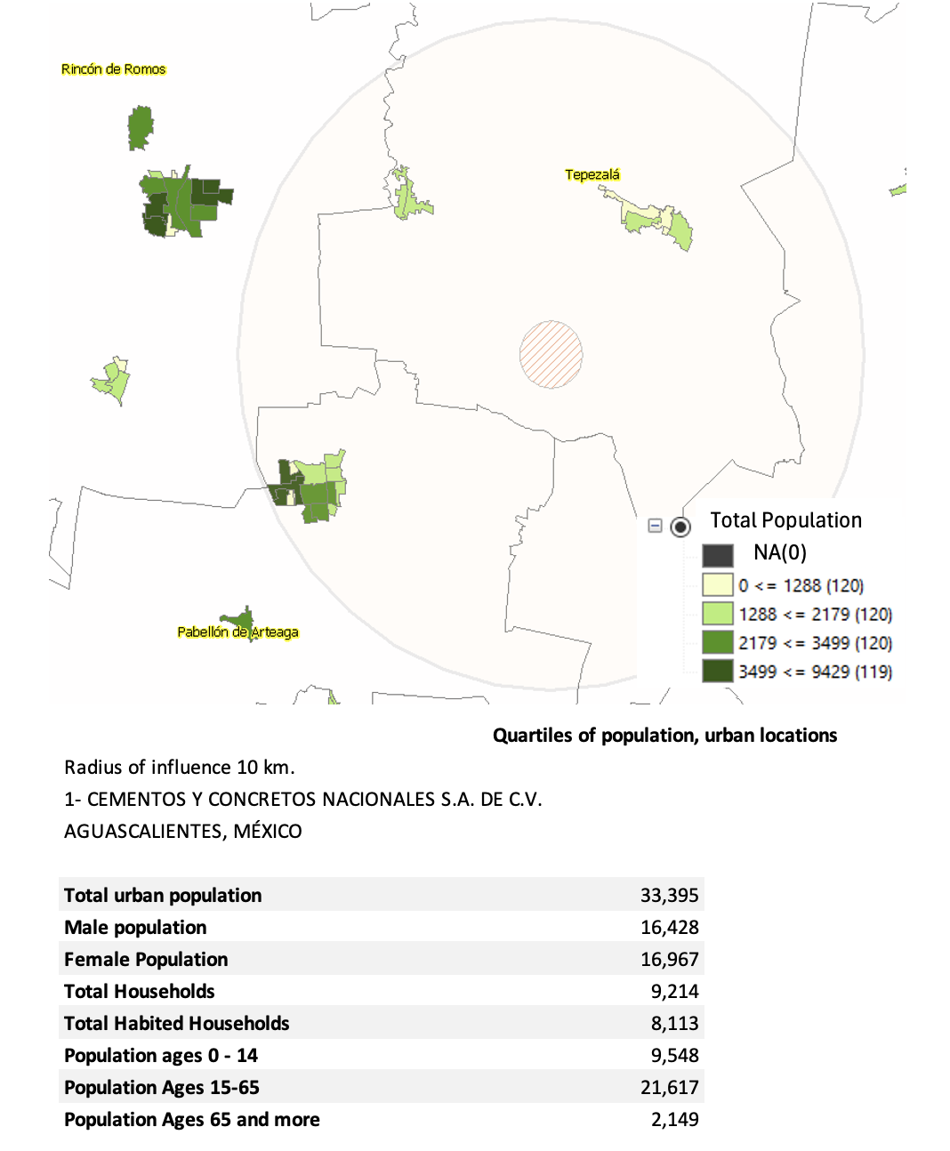
At this facility, energy recovery activities are conducted using hazardous waste such as resins, used oil, solvent and oil mixtures, impregnated solids (textiles, tow, and containers), activated carbon from wastewater treatment plants considered hazardous, lubricating greases, impregnated rubber and plastic with hazardous waste, and garbage contaminated with paint. In addition, the co-processing of materials suitable for use as raw materials in the cement production process in kiln No. 1 and 2 for clinker calcination.
|
| Company | Municipality |
| 2 – CEMEX Planta Ensenada | Ensenada |
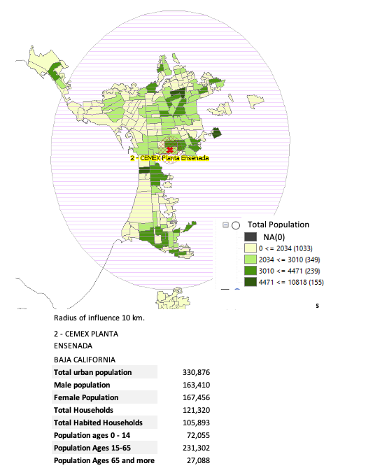
Located in the Northwest region of the state, in the municipality of Ensenada, the CEMEX Ensenada plant is situated in a predominantly urban environment.
Energy recycling and co-processing of hazardous waste or recovered fuels occur here.
| Company | Municipality |
| 6 – GCC Cemento, S.A. de C.V. (Planta Juárez) | Ciudad Juárez |
| 7 – GCC Cemento, S.A. de C.V. (Planta Samalayuca) | Ciudad Juárez |
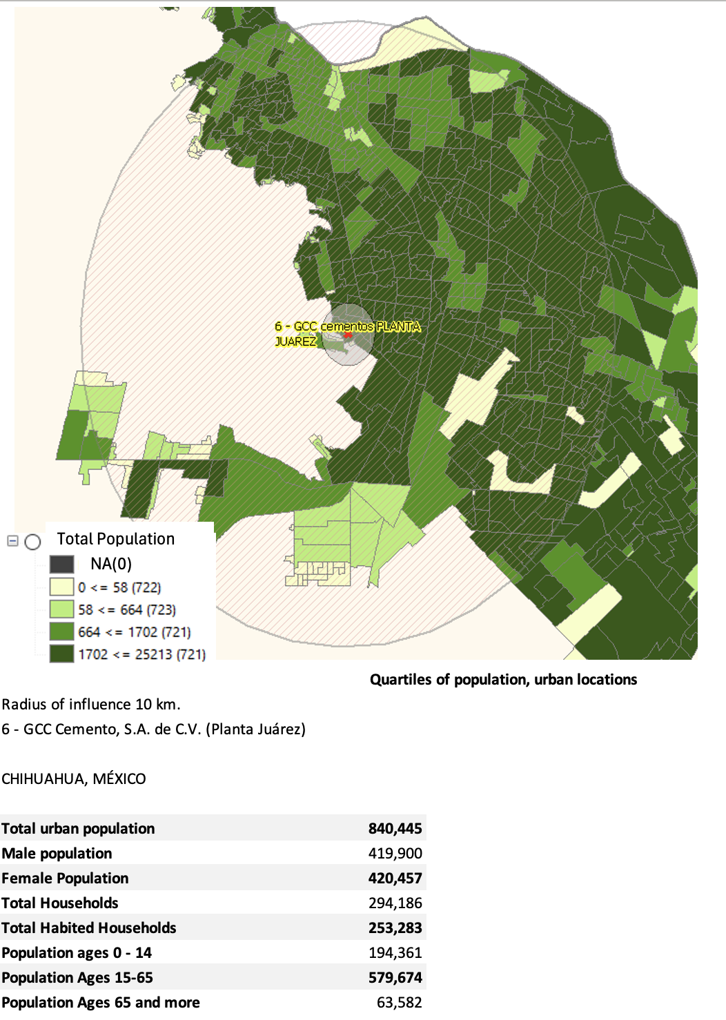
GCC Juárez Cement plant is surrounded mainly by urban areas within a 10-kilometer radius, while the GCC Salmayuca cement plant is in an environment with few rural areas; therefore, there is no population information available. The two areas of influence do not intersect.
The total urban population within a 10-kilometer radius of the Juárez plant is 840,455 people, primarily distributed in the eastern section.
Waste Types:
Used lubricating oils; solid textile materials such as tow, cloths, blankets, gloves, overalls, and flannels impregnated with used lubricating oil; non-chlorinated greases or solvents; contaminated industrial plastic waste; biomass for the formulated and recovered fuels; and hazardous waste suitable for use as raw materials in the clinker calcination process.
| Ecopower Renovables S.P.R. DE R.L. DE C.V. | Chihuahua |
| CADUMA ESTUDIOS Y PROYECTOS S. DE R.L. DE C.V. | Chihuaha |
In the state of Coahuila, two sites are described, located in the southern section of the state, each bordering the states of Durango and Nuevo León.
Activity
| Energy recycling and co-processing of hazardous waste as formulated or recovery fuels |
| Company | Municipality |
| CEMEX | Torreón |
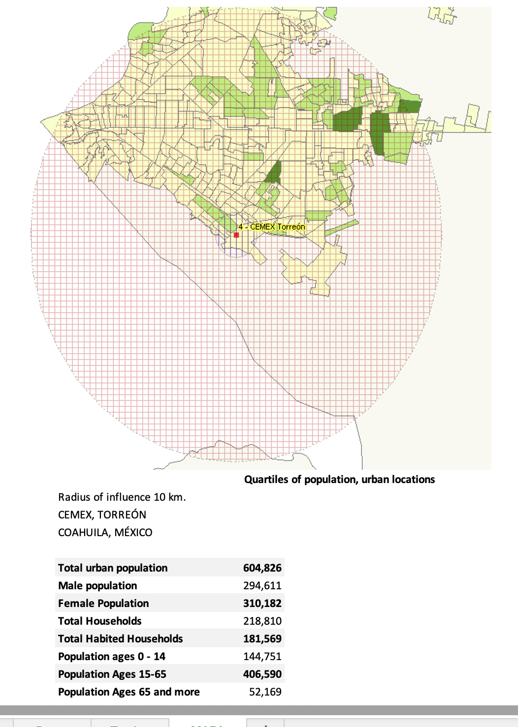
| Company | Municipality |
| HOLCIM | Ramos Arizpe |
| Company | Municipality |
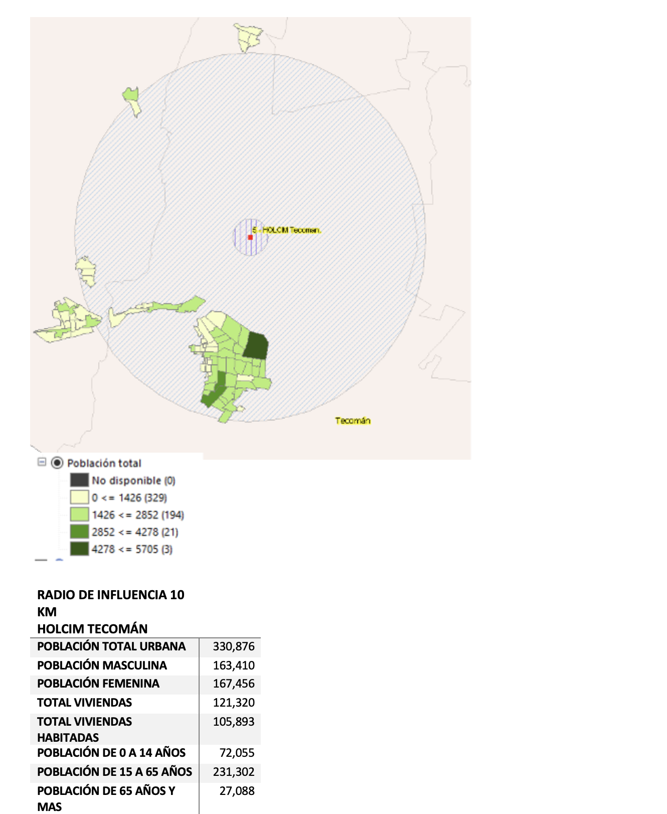
| 5 – Holcim | Tecomán |
|
Activity: Energy recycling and co-processing of hazardous waste as mixed or recovered fuels, hazardous waste such as chlorofluorocarbons, hydrochlorofluorocarbons, and hydrofluorocarbons, as well as their mixtures; empty and perforated containers with propellant (e.g., rust remover spray containers). Within the area of influence, urban polygons are found to the south of the facility, whereas there are a few rural polygons to the north and west. |
| Company | Municipality |
|
15 – Holcim Due to the proximity and intersection of the area of influence with Hidalgo’s state facilities, they are jointly analyzed in the corresponding section for that state. |
Apaxco |
| 16 – CEMEX Planta Barrientos | Tlalnepantla de Baz |
| 17 – Azinsa Óxidos, S.A. de C.V. | Tultitlán |
Activity:
Energy recycling and co-processing of hazardous waste as mixed or recovered fuels.
Three sites are presented in the State of Mexico. Two of them are processed together because of their proximity and overlapping areas of influence:
- 16 – Cemex Barrientos
- 17 – Azinsa Óxidos

 Los sitios marcados con los números de control 16 y 17 se encuentran al norte de la Ciudad de México. Sus radios de influencia cubren municipios importantes como Tlalnepantla de Baz, Atizapán de Zaragoza, Ecatepec de Morelos, Naucalpan de Juárez, Cuautitlán Izcalli, Tultepec y Coacalco de Berriozábal en el Estado de México. Incluso Gustavo A. Madero y Azcapotzalco en la Ciudad de México.
Para el análisis de estos sitios, fue importante crear un polígono que incluyera los radios de influencia de 1 y 10 kilómetros de ambos sitios, y fusionarlos de manera que nos permitiera considerar toda la información geoespacial contenida en esa zona en especial.
Son 3,412,167 personas dentro de los polígonos urbanos que habitan en la gran superficie de influencia de ambos sitios.


| Empresa | Municipio |
| 32 – ENERGÍA TÉRMICA AMBIENTAL, S.A. DE C.V. | Salamanca |
Actividad:
| Co-processing of hazardous waste consisting of textiles, cardboard, wood, paper, and personal protective equipment contaminated with hydrocarbons, solvents, paints, greases, and oils |
In the municipality of Salamanca, in the center of the country, the facility is located whose control number is 32, with authorization for the co-processing of hazardous waste.
The radius of influence shows that the polygons of urban localities predominate, concentrated on the western flank, while the rural ones are located in the northern proximity.
When analyzing the quartiles of the total urban population, it can be seen that the total urban population is distributed mostly to the west of the facility.
The total urban population within the 10-kilometer radius of influence is 194,807 people.

| Empresa | Municipio |
| 8 – Holcim Planta Acapulco | Acapulco de Juárez |
Actividad:
| Energy recycling and co-processing of hazardous waste such as formulated or recovery fuels, empty and full propellant containers (loosens everything sprayed) |
In the city of Acapulco, south of the state, is the HOLCIM cement plant.

Sacrifice Region: Hidalgo – Estado de México
Actividad:
| Energy recycling and co-processing of hazardous waste as formulated or recovery fuels |
Given the importance of the region shared by the State of Mexico and Hidalgo and the strong presence of high-impact industries, four sites are analyzed together due to their proximity: three corresponding to the state of Hidalgo and one to the State of Mexico.
The site marked with the number 11 located in the municipality of Huichapan is shown independently because it is not in the radius of influence of the rest of the sites of this state.
By plotting the 10-kilometer radius of influence from each site in question, the total area resulting from the union of the individual polygons provides interesting information.
| Empresa | Municipio |
| 9 – Trituradora y Procesadora de Materiales Santa Anita, S.A. de C.V. Planta Tula | Atotonilco de Tula |
| 10 – Trituradora y Procesadora de Materiales Santa Anita, S.A. de C.V. Planta Vito | Atotonilco de Tula |
| 11 – CEMEX Planta Huichapan | Huichapan |
| 12 – Cooperativa la Cruz Azul, S.C.L. Planta Tula | Tula de Allende |
| 15 – HOLCIM Planta Apaxco | Apaxco Estado de México |
The radius of influence covers the municipalities of Tula de Allende, Atitalaquia, Tepeji del Río de Ocampo, Atotonilco de Tula in Hidalgo, as well as Apaxco in the State of Mexico.


The splicing of the radii of influence with the basic geostatistical areas indicates that the populations and their polygons are predominantly urban.

The four vectors of the radii of influence are merged to obtain a total surface area that accommodates all the radii of influence of 10 kilometers. This provides a visual guide to the vastness of the territory that is influenced by the existence and operation of these sites. Figure 22
The total urban population of the area of influence created by the splicing of the radii of influence of the sites: 9, 10, 12, 15 of Hidalgo and the State of Mexico is 236,930 people.

Huichapan
Al poniente del estado, se encuentra el municipio de Huichapan, que alberga una cementera CEMEX con el numero de control interno 11.

| Empresa | Municipio |
| 13 -CEMEX Planta Guadalajara | Tlaquepaque |
| 14 – CEMEX Planta Zapotiltic | Zapotiltic |
Activity
|
Energy recycling and co-processing of hazardous waste as formulated or recovery fuels
|
Para el caso de Jalisco se analizan dos sitios que corresponden a plantas cementeras. Ubicados en los municipios de Tlaquepaque y Zapolitic, cuentan con permiso para reciclaje energético y co-procesamiento de residuos peligrosos como combustibles formulados a partir de residuos.
Guadalajara
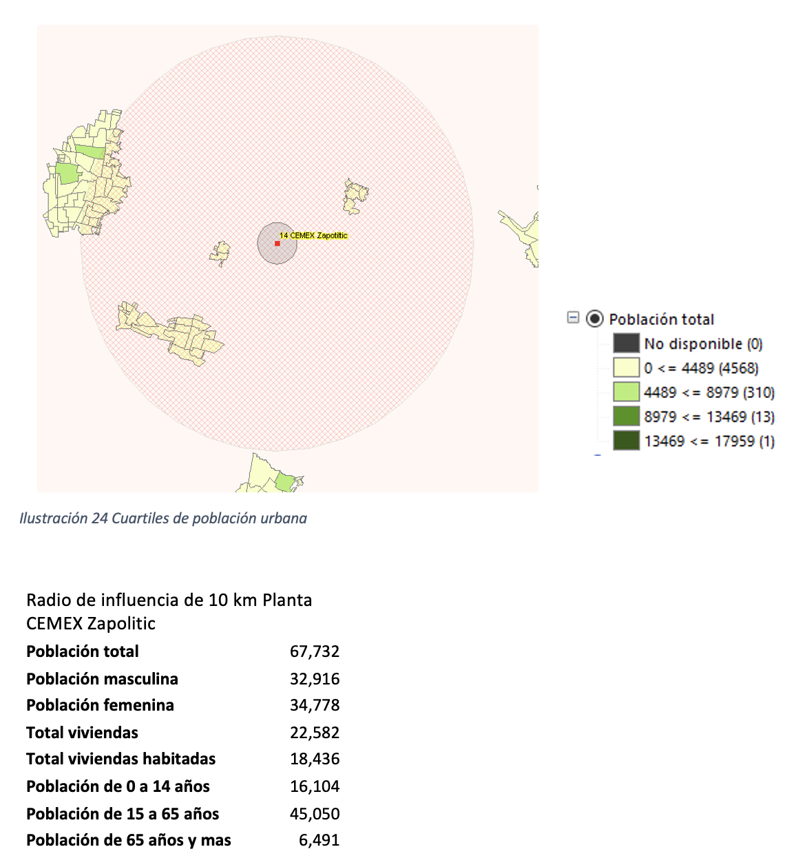
In the case of Jalisco, two sites that correspond to cement plants are analyzed. Located in the municipalities of Tlaquepaque and Zapolitic, they have a permit for energy recycling and co-processing of hazardous waste as fuels formulated from waste.


Zapolitic
This cement plant, which belongs to CEMEX, is located in an area with a lower population density compared to its counterpart in Guadalajara. According to the quartiles of the total urban population, we can say that the population lives mainly outside the radius of influence of 10 kilometers.
The total urban population in the radius of influence of the site with control number 14 is 67,732 inhabitants.
| Empresa | Municipio |
| 18 -Cementos Moctezuma Planta Tepetzingo | Emiliano Zapata |
| 19 – Cementos Portland Moctezuma, | Jiutepec |
Actividad:
| Used lubricating oils; soil, cardboard, paper, textiles contaminated with lubricating oils or greases; textiles impregnated with organic solvents; Hoses impregnated with used lubricating oils. |
Due to their characteristics and geographical location, we obtain from the Geostatistical Information tools that the radii of influence of 10 kilometers for both sites intersect, therefore it is of interest to obtain a large area of influence that associates them.
In the northern zone, the influence extends to the municipalities of Cuernavaca, Tepotzotlán and Jiutepec. To the south are Temixco, Yautepec and Emiliano Zapata.
The total urban population living in the area of influence of . Moctezuma Tepetzingo and Moctezuma Jiutepec Plant is 738,154 people.
.


| Empresa | Municipio |
| 20 – CEMEX Planta Monterrey | Monterrey |
Actividad:
| Energy recycling and co-processing of hazardous waste as formulated or recovery fuels |
La Planta de cementos CEMEX Monterrey está reportada como un operador de reciclaje energético y co-procesamiento de residuos peligrosos como combustibles formulados a partir de residuos.


| Empresa | Municipio |
| 21 – Cooperativa la Cruz Azul, Planta Lagunas | El Barrio de la Soledad Lagunas |
Para el estado de Oaxaca, se procesa la información de una planta cementera Cooperativa Cruz Azul en El Barrio de la Soledad Lagunas.
Con polígonos urbanos ubicados al centro y norte del radio de influencia de 10 kilómetros, se obtiene la población total urbana es de 25,939 personas.


| Empresa | Municipio |
| 22 – CEMEX Planta Tepeaca | Cuautinchán |
Los polígonos urbanos dentro del radio de influencia presentan baja densidad, con una población total urbana de 76,735 personas.


| Empresa | Municipio |
| 23 – Cementos Moctezuma, S.A. de C.V. Planta Cerritos | Cerritos |
| 24 – CEMEX-MÉXICO, S.A. de C.V. Planta Valles | Ciudad Valles |
| 25 – CEMEX-MÉXICO, S.A. de C.V. (Planta Tamuín | Tamuín |
For this state, information is collected from three sites that correspond to cement plants that have authorization for the recycling of hazardous waste as alternative fuels.
The site, marked with control number 23 in the municipality of Cerritos, is located in the center of the state and is analyzed independently because it is not adjacent to another plant or site of interest.

The Cerritos cement plant has a very low urban population density. In the case of the other two sites, Tamuín and Ciudad Valles, the radii of influence overlap, so a polygon is generated that joins both areas. With this information, we infer that the Ciudad Valles plant has the largest population presence in its western part than the plant located in Tamuín.
The total urban population of the catchment area of both plants is 133,071.


Information from three cement plants is shown, one opearating in the municipality of La Colorada, and two in Hermosillo.
| Empresa | Municipio |
| 26 – CEMEX Planta Yaqui | La Colorada |
| 27 – Holcim Planta Hermosillo | Hermosillo |
| 28 – Cemex México Planta Hermosillo | Hermosillo |
Among the activities registered with the environmental authority, they report:
| Textiles impregnated with hydrocarbon derivatives with lubricants, solvents and non-flammable fuels under ambient conditions; sludge generated in paint application sheds; waste that is not reintegrated into the coke production process and cannot be reused; settled sludge and spent solutions generated in wood preservation processes; slag from the scrap smelting furnace in the production of aluminium; sludge from cooling tanks with oils used in hot metal treatment operations; sludge from pickling or degreasing operations; sludge from emission control equipment from electric furnaces in iron and steel production; gas scrubber sludge in aluminum smelting and refining; sewage sludge from air emission washing systems; sludge from monomer storage tanks; sludge resulting from the regeneration of spent cooling oils; solvent distillation sludge; dusts from emission control equipment from electric furnaces in iron and steel production; monomer storage tank bottoms in the production of plastic materials and synthetic resins; depleted activated carbon from the paint booth emissions system; syringe needles, gauze, bandages, and healing material generated in the plant’s office. |
Aunque los radios de influencia de las tres plantas intersecan, los polígonos urbanos se encuentran más allá de los 10 kilómetros de distancia. Por lo tanto, no se cuenta con información de la población total urbana correspondiente a las áreas calculadas.

Actividades :
|
Volatile and non-volatile hydrocarbons (oils, diesel, gasoline and crude oil) from third parties
|
A cement plant and a refuse derived fuel company is shown.
| Empresa | Municipio |
| 29 – Holcim Planta Macuspana | Macuspana |
| 33 – Reind Química, S. de R.L. de C.V. | Jalpa de Méndez |
The location of the HOLCIM Macuspana cement plant has no urban population polygons within the 10-kilometer radius of influence.
In the case of control site 33 Reind Química, if it exists within the radius, it influences urban polygons as shown in Figure 36 with a total of 25,621 people.


Urban areas in the vicinity of the 10 km area are shown in green.
| Empresa | Municipio |
| 30 – Holcim Planta Orizaba | Ixtaczoquitlán |
In the municipality of Ixtaczoquitlán, HOLCIM cement company HOLCIM runs plant in Orizaba.
The urban population polygons in the vicinity of the HOLCIM Orizaba cement plant show that they predominate in the western area. The 10-kilometer zone of influence is home to 321,840 people.


| Empresa | Municipio |
| CEMEX Planta Mérida | Mérida |
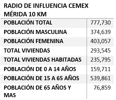
Data from the CEMEX cement plant in the city of Mérida is analyzed.
Located in the city of Mérida, surrounded by urban settings; the total urban population within the area of influence of the CEMEX Mérida plant is 777,730 people.

References
The Total Urban AGEB Population within the 10 km radius of influence were obtained from the «Digital Map of Mexico online version» using as input the vectors of polygons worked with the desktop version, from which the analysis of the different variables is unfolded.
SCINCE 2020
Rural and Urban Polygon Data
for Desktop State-by-State Data Packet with Disaggregated Information


